The industrial revolution created a huge demand for transport. Raw material such as iron ore coal, pottery clay, wool and cotton had to be moved from place to place. Finished goods also had to be moved to cities and ports.
Transport on a horse and cart was very slow. It would take a day to go from Galway to Cong and the maximum you could carry would be one tonne.
The time from the industrial revolution in the 1820's to the development of railways in the 1850's was the golden age for building and using canals. At that time anywhere an engineer saw two pieces of water close together on a map he thought about joining them with a canal.
THE CONG CANAL
The Cong Canal (Drumsheel)
The idea was to join Lough Corrib to the sea and link the north of Lough Corrib to Lough Mask and Lough Carra with a series of canals.
This would allow trade between Galway city and Castlebar as well as all the other towns along the route, a very appealing concept to merchants, boat owners and landowners.
The canal was first mooted in a parliamentary report on canals in 1815. Further reports were produced by a select committee which included as a member Dominick Browne – owner of Ashford House.
Further reports were produced by a select committee which included as a member Dominick Browne – owner of Ashford House. Further work was carried out by the engineer William Bald and an 1844 account of the "Industrial Resources of Ireland" proposed a waterway linking lakes throughout Connacht to create a navigable waterway from Galway to Ballina.
In 1844, the Commissioners of Public Works asked their engineer John McMahon to assess the proposal. His report was published in 1846.
In 1848, Samuel Roberts was appointed as Superintending Engineer and began work on the Canal in September of that year.
The work was not intended as a Relief project, but it did provide much needed work for the population of the Cong area. The estimated cost for the work was £48,178. The canal would run for a little over four miles and required three locks to make the thirty six feet drop between the two lakes.
The project was expected to employ between 300 and 500 workers during the construction phase.
Work progressed rapidly during the early years of the project. Samuel Roberts, the engineer for the project, took advantage of the low water in the summer to build a head dam across the inlet from Lough Mask.
Any water in the excavated canal would drain through the porous limestone. During the winter month’s work continued at the southern end of the Canal.
In April 1854, the Commissioners directed that work on the navigation aspect be discontinued. Some drainage work was continued to enable the level of Lough Mask to be regulated.
The official reasons were set out in a report to the Commissioner of Public Works which states that increasing labour costs and the spread of the railways made the canal and onward navigation North through Mayo unfeasible. Sir William Wilde advanced another reason in his book about Lough Corrib.
William Wilde:
“A project was entertained of opening up a free communication through the great chain of lakes – Corrib, Measca, and Cearra – with the harbour of Gaillimh and much expense was incurred in constructing a canal, locks, and other works for that purpose. Before they were completed, it turned out to be a failure... for it was discovered, that like many other undertakings, the great canal at Cong “would not hold water.”
Wilde's feigned ignorance of canal construction created the myth of the "Dry Canal" which persists to this day.
In fact, the engineers were well aware of the need to staunch the canal – a common technique in canal construction – and had allocated funds for the purpose. The following two extracts from McMahon's report make this clear:
John McMahon:
“It was ascertained, by a careful survey of the country lying between the northern end of Lough Corrib at Cong, and the most easily approached shore of Lough Mask, at Ballinchalla Bridge, that an effective communication was attainable by the construction of staunch canal, about four miles in length, carried over the cavernous limestone lying between the two loughs.”
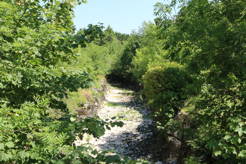
Not only was the canal described as a staunch canal but the sum of £5,747 was allocated for puddling. The unfinished canal lies to the east of the village and sections may be visited.
VISITING THE DRY CANAL
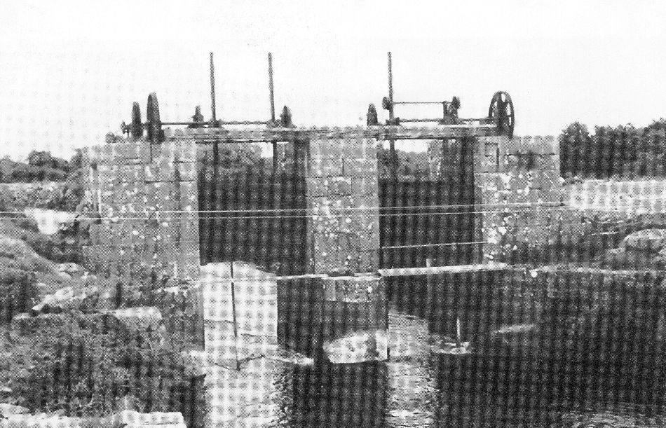
For instance, the entrance to the canal from Lough Mask. Just south of the entrance are the regulating sluices that were built in the late 1850's to control the level of the lake and ensure that the mills in Cong received sufficient water during the summer.
The Sluice Gates
The Cong Canal (Drumsheel)
FAMINE RELIEF
The building of the canal must have provided badly needed jobs in an area wrecked by famine but it did not save the Cong area from an awful population decline.
From the census figures we learn that the decline in population in Cong Parish from 1841 to 1861 was 37.6%. The drop for Mayo in the same period was 34.4% which means that Cong area fared slightly worse than the rest of Mayo.
At the north end of the village, the Drumsheel Bridge carries the road way over the canal. The bridge also carries a benchmark that was used by Ordinance Survey as an elevation reference in the 19th Century.
Just before the Drumsheel Bridge, there is a roadway to the left which crosses a bridge over the overflow channel for the canal. The overflow channel was constructed to ensure that there was sufficient water to power the mills around Cong. The overflow channel exits into the river close to the forge just north of the village.
In the village itself, there are two bridges that were built in 1852. The first, bridge crosses the dug-out channel of the canal. The second carries the realigned road over the river. To the south of this bridge, the dug-out channel was excavated as far as the Cong River opposite Ashford Castle.
The entrance to the canal can be seen just to the north of the bridge at Ashford Castle. The first lock was to have been located close to the entrance to the canal. Part of the canal was filled in during the late 19th century to provide the access road between the castle and the village.
A gate was created to allow horses to pass under the road. The canal had no tow path at this point. There are also some large masonry blocks at this point which were intended to form part of the rebuilt second lock.
The Third Lock is located just beyond the new children's playground and car park beside the Old Mill. The viaduct would have carried the canal over the river.
ST CECILIA'S WELL
St. Cecilia's well
This was a place of pilgrimage during times past and people would travel from all over the countryside for an all-night vigil. Local lore suggests the site also played host to women who had not found a suitable suitor. The allegedly hung their petticoats on the tree above the well and uttered the following prayer:
Woman (whispers her prayer) :
“Holy Saint Anthony, Holy Saint Anne, Send me a man as fast as you can!”
THE CAVES OF CONG
The Pigeon Hole
There are a large number of caves located in the Cong district. Most of them are natural but some have evidence of human activity.
It is well known that the waters of Lough Mask flow through Cong in a series of underground rivers and streams until they reach Lough Corrib.
The reason for all of the underground caverns and caves is because the area around Cong is largely made up of carboniferous limestone through which the water has penetrated over many centuries. This has resulted in the formation of caves.
Many of the known caves have legends and stories associated with them. Some were discovered accidentally and it is believed that there are many more unknown. During the 1940's, a horse and plough disappeared into a hole in the ground that opened beneath them. This was named Horse Discovery Cave.
In another incident, a goat fell into a hole, but luckily the animal was rescued as it landed on a ledge about forty feet underground. The cave was much deeper and was unknown until it was discovered by the goat. Incidentally, the field was known as Cluain na Marbh, translated to the Meadow of the Dead.
There is another story of a flock of geese gliding along into an underground river; they could be heard in caves a good distance away.
Another story involves a goose that strayed into a swallow hole named Poolmore and wasn't seen again for three weeks.
After the bird reappeared it was affected by the daylight and died shortly afterwards. Some of the water holes and streams have very interesting Irish names, such as Coisceim na Caillige (footsteps of the hag) and Poll na Sideog (Water-hole of the Young Fairies).
In many of the caves there are stalagmites and stalactites which have formed over thousands of years. These dark and unearthly looking caves are said to be the abode of fairies, leprechauns and banshees.
They are also supposed to be the last refuge of the Tuatha Dé Danann. These were the race of magicians who after they lost their power above ground, turned themselves into fairies and now reside underground.
In years gone-by people said that on moon-lit nights, one would often see these fairies dancing in the fields near Cong. Some said they continue to dance in celebration of their victory over the Fir Bolg after the Battle of Moytura
It has been said that the banshee of the Fir Bolg can also be heard, keening over the defeat of her people, where the "Hags Foot" was once situated.
Cong is a place rich in legends and the following are just a sample of these stories associated with some of the caves of Cong.
KELLY'S CAVE
This is a good example of a cave that is part natural and part artificial. It is maintained as a national monument. It consists of two rectangular compartments 10 to 12 ft. in height, one 11ft. by 6ft. opening into a deeper chamber 45ft. by 11ft.
A natural skylight gives a little light at the end of the cave where three stone steps descend to a trough along which an underground stream passes.
The cave was, very probably, used as a dwelling-place during contingencies in the very earliest times, but it was a much later occupant, a fugitive of the 1798 Rebellion who used it as a hiding place, that the cave got its name.
Kelly's Cave
The story goes that Kelly was a man who was forced to live there, along with his family, during the penal times. He subsequently became a robber in order to survive.
It was recorded in the mid-twentieth century that an English archaeologist once visited the cave and said that there was evidence of prehistoric people found there.
He also said that Kelly's Cave resembled in some aspects of the rock-cut tombs in Sardinia and other Mediterranean sites.
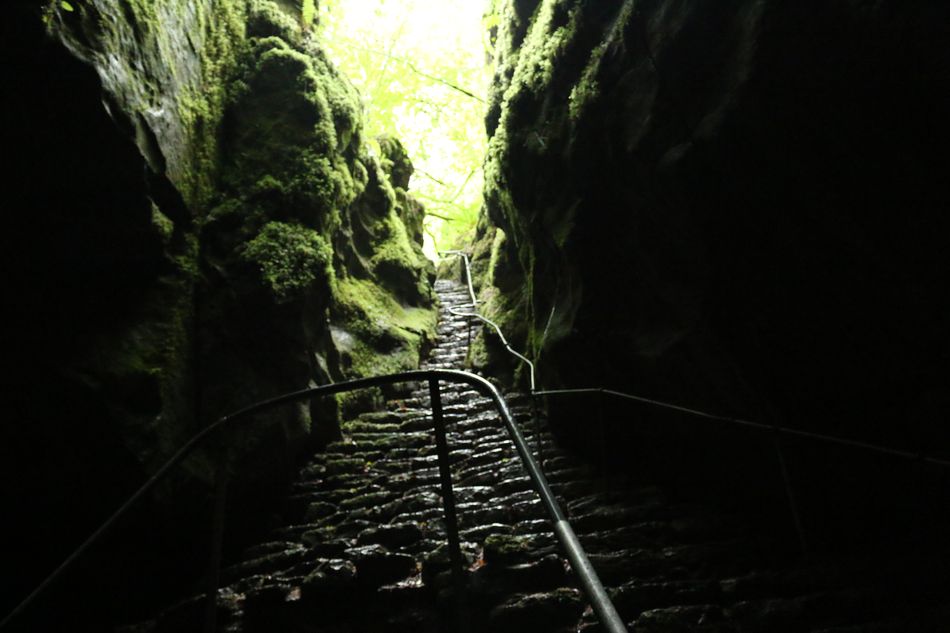
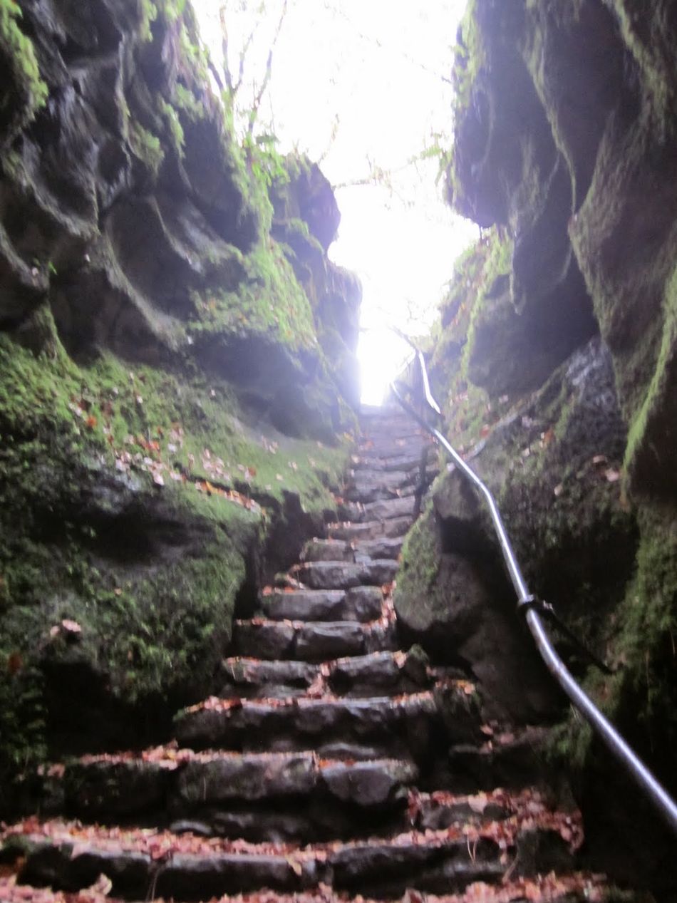
THE PIGEON HOLE
Pigeon Hole
Sixty one artificial steps, hewn from solid rock, make a steep stairway to the bottom of the hole. The bottom is a dark, weird, ghostly place where the underground river rushes through.
It has been suggested that in summer, when the river bed is usually dry, a silence, broken only by the drip from stalactites into the dark waters, adds to the eeriness of the cave.
The underground chamber measures 120ft. from north to south and averages 30ft. in width.
THE FAIRY TROUT
“Ye Pigeon Hole of Storied Fame; Ungallant was that soldier, Who thus did fry that noble Dame, That came from regions colder."
The Fairy Trout
One would need to enter at least a short distance into the darkness to chance seeing the fairy trout that, legend says, inhabit the pools of the Pigeon Hole. Unnatural fish they are indeed, for it is well known that no Pigeon Hole trout has ever taken a bait.
A story tells us how at least two of the charmed fish came to live there. A young and beautiful maiden was betrothed to a noble youth whose castle stood on the shores of Lough Corrib. They were very much in love and very happy.
But, one night, jealous rivals waylaid the young man, struck him down, and threw him into the lake to drown. He was never seen again, but it was noticed immediately after his disappearance that a strange trout had appeared in the waters of the Pigeon Hole.
The young maiden, bereft of her lover, was overcome with grief. She slowly pined away and, eventually, simply vanished. On her disappearance, a white trout joined the other in the pool.
The fairies had taken pity on the young lovers and had united them once more. The pair have never since been separated. Never, that is, except for one brief period when the Red Coat took the white trout from the stream...
To disprove the legend for a wager, a red-coated English soldier undertook to catch the white trout, cook it, and eat it. Catch the fish indeed the soldier did, and he proceeded to fry it over a fire and kindle.
When the burning grid touched its side, the trout leaped away from the flames. As soon as the white trout touched the ground it became a young maiden of extraordinary beauty. The tearful girl told the soldier of the sad story of her love and entreated him to return her to the water.
Deeply moved, the Red Coat reverently replaced the maiden in the stream and, once more, she was transformed into a white trout, but now a scar showed on the fish’s side from the burn on the grid. The Fairy Trout carries that mark to this day.
Ballymaglancy Cave
THE PRIEST'S CAVE
"The cave is located about 300 metres from the Pigeon Hole. The tradition with this cave is that priests used to take refuge there during the Penal Laws of the 18th Century. There is one stone in the cave that is said to be discoloured by the blood of a priest who was betrayed by the infamous priest hunter Seán na Sagart (Jack of the Priests)".
BALLYMACGLANCY CAVE
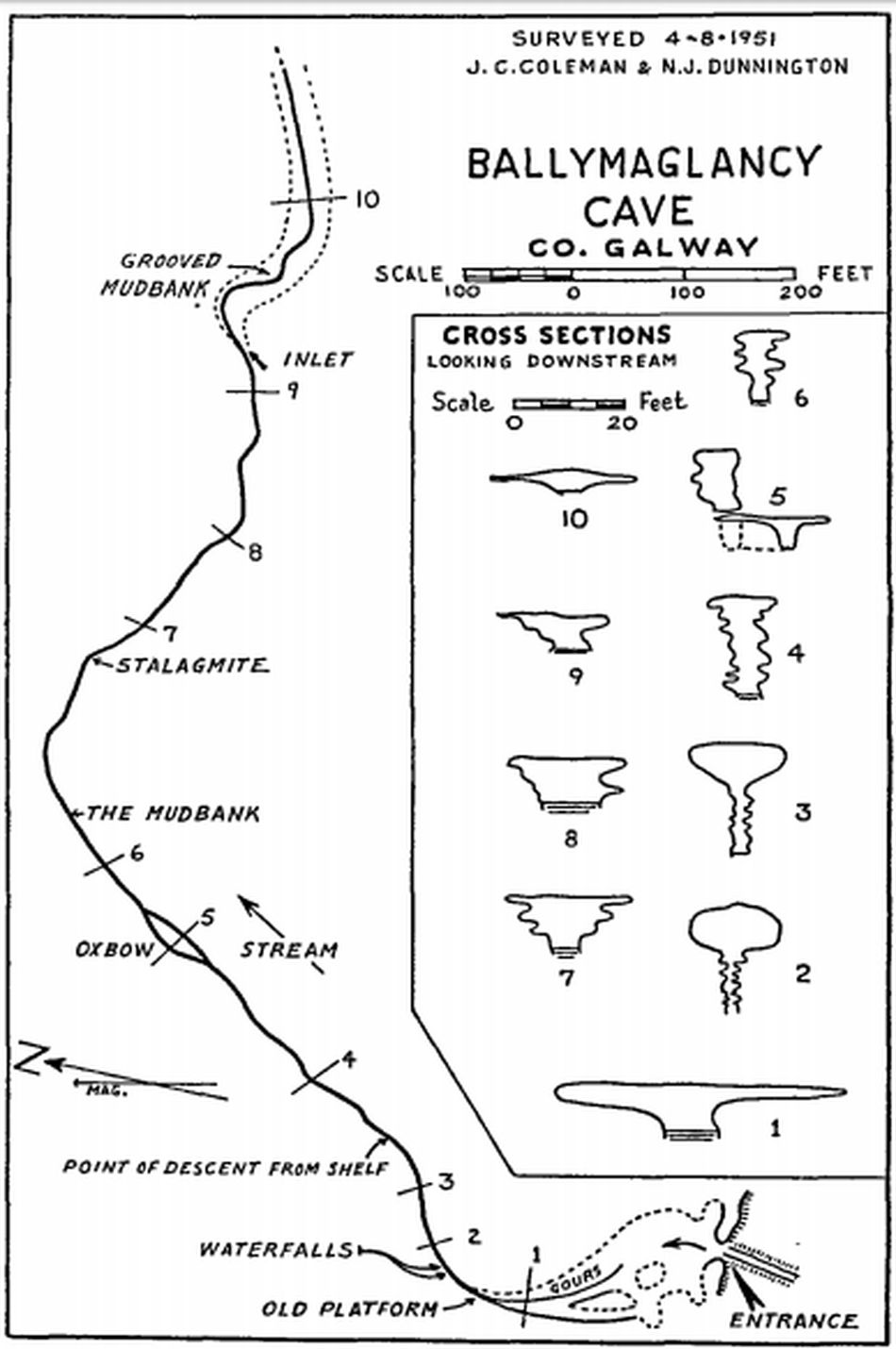
Ballymaglancy Cave map
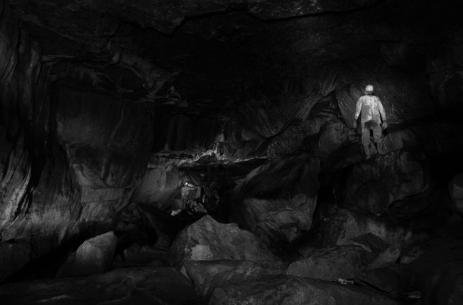
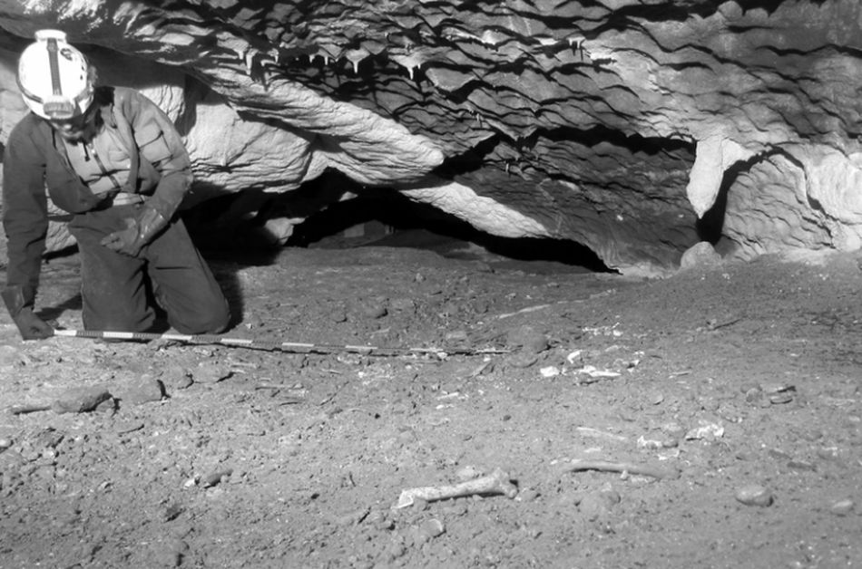
Ballymaglancy Cave, two miles to the west of Cong, has been explored to a distance of 1,700 feet. A deep stream flows through the cave and in exploring, it is necessary to crawl along hazardous rock shelves and through holes formed by stalagmites.
At a distance of 200ft. from the cave mouth the stream cascades to a drop of 12ft. Visitors seldom go beyond this waterfall, because 130ft. farther in there is a sharp dip of 16ft. in the level of the cave floor.
The cave is remarkable for the curious formation of the limestone rock that juts out as shelves from its walls. Stalactites meet stalagmites to form grotesque figures and pillars.
A group of the finest stalagmites, locally called "The Saints" was destroyed at the end of the last century, by a landlord who was disturbed by their religious appearance.
Human skeletons were found deep in the cave in the early 20th century. A quern discovered near the entrance has since been removed.
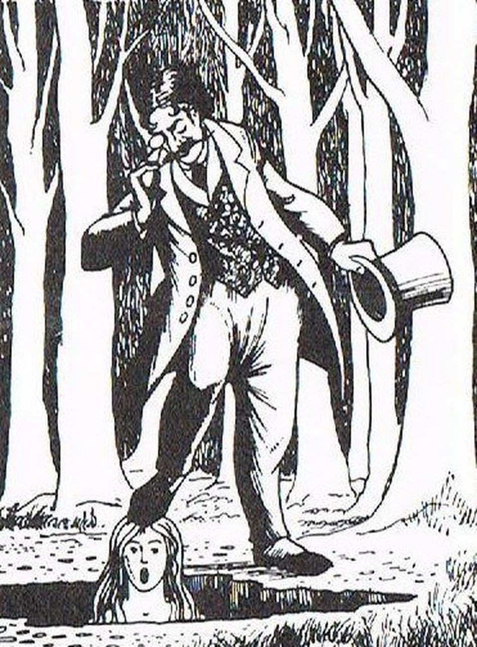
CAPTAIN WEBB'S HOLE
Captain Webb, of ill fame, gave his name to a dark, dangerous-looking hole among the trees 200 yards to the west of Kelly's Cave.
The following is the account of Captain Webb from a book 'Ancient Legends, Mystic Charms, and Superstitions of Ireland' produced by Lady Jane Wilde from a collection of her late husband William's notes:
“He was a most notorious robber who used to make the County Mayo his headquarters and dreadful tales are still current amongst the people of his deeds and violence and cruelty"
Captain Webb and victim
Many beautiful young girls he carried off by force or fraud; and when he grew tired of them it was his practice to strip the unhappy victims naked, and plunge them down a deep hole near Lough Corrib.
One day however, fate worked out a revenge on the audacious highwayman by the hands of a woman. He had committed a daring robbery on the highroad – plundered a carriage, shot the horses, and carried off a noble and lovely girl, who was returning home with her mother from an entertainment, which had been given by a great lord in the vicinity.
Consequently, as the robber knew, the ladies were dressed magnificently, and wore the most costly jewels. After stripping the mother of all her ornaments, he left her for dead upon the highway; but wrapping a cloak round the young lady, Captain Webb flung her on the horse before him and galloped off to one of the many hiding-places he had through the country.
For some time he gave up all his other favourites for the sake of the beautiful girl, and carried her about with him on his wild expeditions, so great was the madness of his love for her.
But at length he grew tired even of her beauty, and resolved to get rid of her, in the same way as he had got rid of the others, by a cruel and sudden death.
Account of one of Captain Webb’s would-be victims:
“I had been his prisoner for a considerable time at this stage. He forced me to attend his midnight raids and help him make off with the stolen goods. I knew he was growing tired of me and I would not be long for this world. I rode one of his steeds beside him on that fateful night. He brought me to the fatal hole where so many of his victims had perished, intending to cast me down headlong as he had done to so many others.
First, he told me to dismount and to take off all my rich garments of silk and gold and jewels, for he said I would no longer need them.
“For pity, then” I said, “do not look on me while I undress, for it is not seemly or right to look on a woman undressing; but turn your back and I shall unclasp my robe and fling it off.”
So "The Captain, as the rogue referred to himself, turned his back as he said he could not refuse my last request; but still he kept close to the edge of the hole ready to throw me in; when suddenly I sprang upon him and placing both hand on his shoulders, pushed him over the edge, down into the fathomless gulf, from which no mortal ever rose alive. The country was freed for evermore from the terrible robber fiend and I had finally avenged my mother's untimely demise”.
THE LADIES BUTTERY
This is a naturally formed cave situated off the Galway road near the gates to Strand Hill. Turn right at these gates and follow the pathway to the cave. The cave takes its name from the tradition of housewives using it to store butter. It was said that the coolness of the cave helped keep the butter fresh.
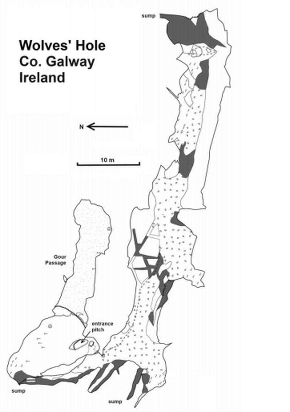
THE WOLVES HOLE - THE DOG'S CAVE
This lies in a hillside to the north of the path. It is identified on old maps as the Wolves Cave or Wolves Hole because of bones identified in the cave as wolves bones.
The Wolve's Hole - The Dog's Cave Map
The French father of modern speleology Edouard-Alfred Martel visited the cave in 1897 and refers to it in “Irelander et Caverns Analgises” as “le trout sans nom” - the unnamed hole. The cave was renamed the Dogs Cave in 1972 after four skulls were removed from the cave and identified as dog's skulls.
Surveying the Dog's Cave
TEACH AILLE (THE HOUSE OF THE CLIFF)
Only 600 yards from Cong Abbey and twice that distance from Ashford Castle by the river walk, Teach Ailed is a picturesque natural grotto where the underground river shows itself for a moment. The opening above the surface of the ground is roughly 30ft. by 20ft. fifteen steps lead to the sandy bottom of the stone chamber and a stream of clear water passes through. It is likely that the monks of the Abbey drew their supply of drinking water from the stream. According to local folklore, the Abbey used the cave as a cold store for provisions.
HORSE DISCOVERY
The cave was named because a man out ploughing discovered it when his horse broke through the roof of the cave.
Horse Discovery map
This isn't the only time a horse had "discovered" a cave in the Cong area. The following account from the 1930's describes a local man going out to feed his horse:
“Outside the picturesque village of Cong in Co. Mayo a local farmer walked to one of his many fields to gaze upon and feed his prized horse. As he approached the gate, he could see the horse standing in the field. He opened the gate and entered the field. As he turned to close the gate, he heard a noise behind him.”
GEORGE McNAMARA - THE ROBIN HOOD OF CONG
Born in 1690 in County Clare, he was known as a "Robin Hood of the Irish who risked his life and his all on many occasions to ease the burden of the poor and friend of the oppressed peasantry" (ITATGS, 1945) in the 1700's and "whenever an account came of eviction or other ill-treatment he was off immediately to raid and rob the wrongdoer or some other more convenient malefactor - distributing the spoil equitably amongst the deserving" (ITATGS, 1945).
George McNamara
Though himself a landowner, he championed the cause of the much oppressed tenants of those unhappy days and became their Robin Hood.
He could see that there was no way in which the tenant farmer could improve his lifestyle or conditions for their families. If they made an improvement on their leased land hold this encouraged the landlord to levy more taxes.
Eviction was the greatest fear of these tenants, and McNamara endeavoured to use his skills and local knowledge to “disown” some of the irresponsible and cruel landlords and make the poor tenants the benefactors.
Tradition tells us that McNamara’s kitchens were always stocked with foods, which he generously shared with his neighbours. He had a brewery, a fishery, and also ran a farm, so could supply various foods to those in need.
George McNamara after a robbery
Leading a double life, McNamara was the perfect host to the local gentry whom he frequently and lavishly entertained in his fine house while, secretly, he relieved them of their valuables in nightly raids on their mansions.
George McNamara in Cong Village
McNamara used an underground secret passage from his house to the village for going and coming unsuspected in his nocturnal adventures. The proceeds of his burglaries he gave to his needy tenants.
A peasant threatened with eviction for being unable to pay a rack-rent, or with prison for failing to pay a fine, could always rely on the support of George McNamara.
Around the firesides of the tenantry, thrilling tales were told of his daring raids and of the super equine feats of his wonderful bay mare, Venus.
George McNamara and Venus
Venus once carried him to Co. Clare, 60 miles away, and back between sunrise and sunset.
Again, in a midnight chase through the mountains, she jumped a thirty foot ravine to save her master from the wrath of the ferocious O'Flaherty's, who then lorded the Connemara regions.
The place where this was done is situated within about half a mile from Maam, where the lodge or hotel now stands. It is still known by the name of “McNamara's Leap”.
George McNamara was a strong, agile and handsome man. He was a superb sportsman. He was well known for his horsemanship skills and was also reputed to be an excellent marksman.
Eviction was the greatest fear of these tenants, and McNamara endeavoured to use his skills and local knowledge to “disown” some of the irresponsible and cruel landlords and make the poor tenants the benefactors.
Another story from Patrick Higgins' book 'A brief sketch of the romantic life of George McNamara of Cong Abbey' (1899), described our heroes escapades in a court room:
“McNamara was apparently the terror of many wherever he wont, some of his neighbours betimes not expected nor exempted from suffering at his hands. At Tullaghaun or Strandhill, there lived in his time a gentleman of the name of Stephen Dean, with whom McNamara quarrelled. Subsequently, Dean and two of his dependents meeting McNamara on the road near Strandhill, at a spot where a horse of Dean's was grazing, they alleged he was stealing the beast. For this, he was obliged to stand his trial at the ensuing assizes, but was somewhat favoured by one of the present Lord Kilmaine (possibly Sir John Browne) more through terror than love it is said, who interfered on his behalf with the judge. When McNamara saw things turn up rather favourably in his behalf, he sprang out of the dock over spikes and all, though handcuffed and wearing bolts and fetters on his feet; at which the judge's gravity gave way to a smile and then to amazement, as well as that of the whole court.
He then requested to be allowed to show them a little of what his companion Venus could do; and without delay mounted the noble beast trotted down to the bridge at High Street, got her up on the battlement, where he trotted the nimble and sure footed animal, which could certainly vie with any mule used in the Alps of mountains of Switzerland; he then got down on the bridge again, and several times got her over the battlement to her hind legs, to the utter astonishment of a crowd of spectators. He was known to have the shoes turned on her in order to elude the discovery of his pursuers, who were by this ingenuity led to take a contrary direction to that taken by him. (The anvil of which McNamara had Venus' shoes made is still preserved in Cong village).
When Venus' term of companionship had expired, he had her waked, and coffined, and buried with pomp, by giving many bumpers of "mountain dew", with which he was always plentifully stocked, to the persons who surrounded her grave.” (In the original version, Venus was named Binnis)
McNamara gave open support to the tenants. But in the Ireland of those days, philanthropists were inevitably on the losing side. George McNamara died a pauper. He is buried by the sedilia in the Abbey Chancel.
ASHFORD CASTLE
1228 – DE BURGO NORMAN FORTRESS BUILT
The original De Burgo Norman fortress
The first structure built on the site where Ashford Castle currently exists was a Norman fortress.
Constructed and inhabited by the De Burgo family, it was one of many Norman castles built around the shores of Lough Corrib at that time. Its foundations stones were laid around 1228 AD.
It's believed the location of the fortress was strategically placed as it would have protected the narrow corridor of land between Lough Corrib in the South and Lough Mask in the North.
Connemara, to the west, was occupied by the O'Malleys and the O'Flahertys, while to the East were the more fertile plains of Co. Mayo controlled by the De Burgos.
The lakes provided natural obstacles for any major attack leaving the Normans to protect only the isthmus of land in between.
1715 – FRENCH STYLE CHATEAU BUILT BY LORD ORANMORE AND BROWNE
The De Burgo's, later Burkes, married into another Norman family, the DeBruns (later changing their name to Browne, a family associated with Westport House and Castle Garret.) This family built a French style chateau, separate from the original structure that is still incorporated in the centre of the castle today.
1852 – BENJAMIN LEE GUINNESS PURCHASED THE ESTATE
During the famine years (1847-1852), the castle fell into disrepair as the tenants on the estate were simply unable to pay the exorbitant land rents.
By 1852, Lord Oranmore and Browne declared himself bankrupt and he was forced to put his estate up for sale. In the same year, Sir Benjamin Lee Guinness of the famous brewing dynasty purchased the estate, a move that would eventually bring better times to the area.
Ashford and its surrounding 1,179 acres were acquired through the Encumbered Estates Court by the Guinness’s for £11,005.
Sir Benjamin Lee Guinness
THE GUINNESS TOWER
Following his purchase of the Ashford Estate in 1852, Sir Benjamin Lee Guinness set about improving the house and estate. He created the basic structure of the formal gardens that can be seen today and also created a woodland garden that has been taken over by the tree planting to the west of Cong River.
The most visible element of the garden today is the Guinness Tower – a folly that allowed Sir Benjamin to view his sprawling estate from the top.
Leonard's Tower
The tower was completed in 1864 and contains much fine stonework. Seventy nine steps lead upwards to a small room that opens out onto the roof. The surrounding trees obscure most of the views today.
Locally, it is referred to as Leonard's Tower after Alfred Leonard who served as Head Forrester for the Forest Service in Cong from 1941.
Even in those days, the Guinness family were one of great affluence and between 1875 and 1915, they spent a total of one million pounds renovating the castle to its former glory. Shortly before the commencement of this work, Sir Benjamin Lee Guinness died and his son Arthur Guinness (Lord Ardilaun) inherited the estate.
Countess of Bantry, Lord and Lady Ardilaun
In 1871, Lord Ardilaun married Lady Olivia White, daughter of the 3rd Earl of Bantry and together they were to enhance and adorn their summer residence. During these times the Guinness family created a wonderful legacy of good piers, improved roads and many majestic bridges all of which can be seen today.
In addition, the planted thousands of wonderful trees throughout their 3,500 acre estate. Many of these trees are still testament to that time.
In 1880, Arthur received the title of Barron Ardilaun. The name was taken by Arthur after his favourite island on Lough Corrib "Ard-Oilean" (High Island).
The couple liked to take a walk to a chalet about a mile from the castle, where they would have tea and took in the majestic views of the lake including his chosen Island.
During this era, the Guinness family played host to many renowned guests at Ashford including George V, Prince of Wales and future King of England. He visited Ashford in 1905.
The visit of the Prince of Wales and future King George V
Lord Ardilaun died in 1915. Upon his death, Lady Ardilaun erected an obelisk to his memory.
Lord Ardilaun's Chalet and Obelisk
The limestone obelisk is about fifteen feet high and stands facing Ard-Oilean. The obelisk bares the inscription "Rien ne m'est plus; Plus ne m'est rien" which means "Nothing remains to me any longer, anything that remains means nothing".
As Lord Ardilaun had no heirs, his estate passed into the hands of his brother Edward Guinness (1st Earl of Iveagh) who was at that time head of the Dublin brewery.
After his death in 1927, his son Ernest Guinness was to be the last member of the Guinness family to own this majestic estate.
Ernest Guinness (Lord Iveagh) had his own sea plane which he used to land on Lough Corrib at the front of the Castle.
Hunting party
1939 IRISH STATE PURCHASED THE ESTATE
In 1939, he sold the estate to the Irish state for a token fee of £20,000. In reality, this was a gift to the Irish people by the Guinness family.
1939 NOEL HUGGARD PURCHASED THE LEASE
In 1939, the tenants on the estate got to own their own farms through the "Land Commission Scheme". The Forestry Department took over the wooded area of the estate.
This left about 350 acres and the castle itself which were leased out on a 45 year lease to a Kerry man, Noel Huggard. This move was to mark the end of an era. No longer a private residence, Ashford Castle became the prestigious hotel that we know today.
To a large extent, Noel Huggard, already an experienced hotelier was responsible for placing Ashford Castle among the most renowned hotels in Europe. In these early days he attracted war officers who had returned from the front in Europe to fish and shoot.
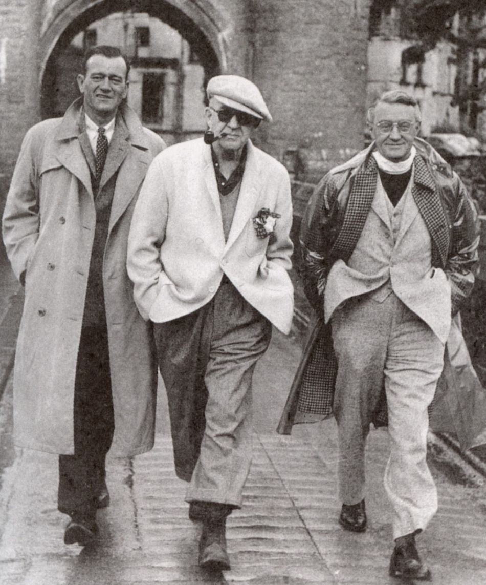
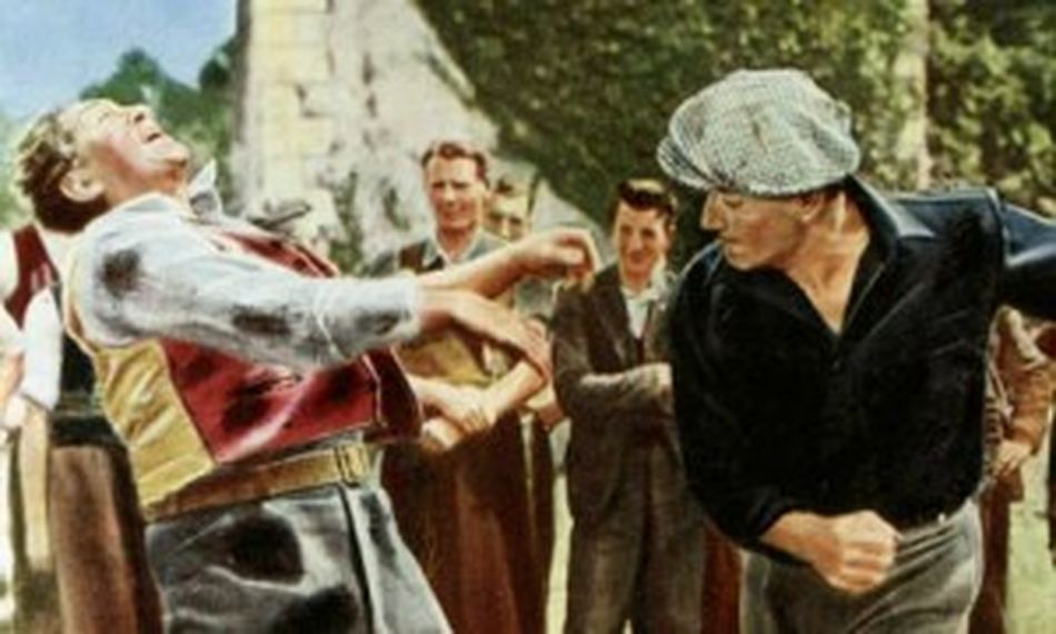
1951 FILMING THE QUIET MAN
John Wayne, John Ford & Arthur Shields
Fight scene from "The Quiet Man"
In more recent times, there was one single event that launched Ashford Castle onto the world stage and that was the making of the classic movie, "The Quiet Man", filmed here in 1951.
Director John Ford had intended making the movie in Spiddal, Co. Galway where his predecessors came from. However, having seen Ashford Castle in all its splendour, he quickly changed his mind and set up camp in Cong along with screen legends John Wayne and Maureen O'Hara.
The movie took about ten weeks to make and many locals took part as extras.
1969-70 JOHN A. MULCAHY PURCHASED THE LEASE
In 1971, Mr. John A Mulcahy, an Irish American businessman purchased the lease of Ashford castle. He also began renovation work and added on 40 bedrooms, now called the new wing.
Another milestone in the history of the castle was the arrival of President Ronald Reagan in 1984. The American administration chose the, by now, world renowned hotel as their abode for the President's State visit. Once again, the eyes of the world focused on Ashford Castle.
1985 IRISH AMERICAN INVESTORS PURCHASED THE LEASE
In 1985, the lease of the castle was purchased by a group of Irish American investors. These investors included Tony O'Reilly, former director of Heinz foods and the Rooney family, owners of the Pittsburgh Steelers.
2003 RED CARNATION GROUP
In May 2013, Ashford was bought by Red Carnation Hotels and they began a major refurbishment to bring the castle back to its former glory. As part of the new refurbishment, Ashford Castle introduced a 30 seat cinema, luxurious billiards room and Cigar Terrace.
In 2014, The Lodge at Ashford was acquired by the group. In August of that year, Ashford Castle introduced the brand new state-of-the-art Spa, wine tasting tunnels and was voted.